
Our ATUR Project Approach
Project Structure
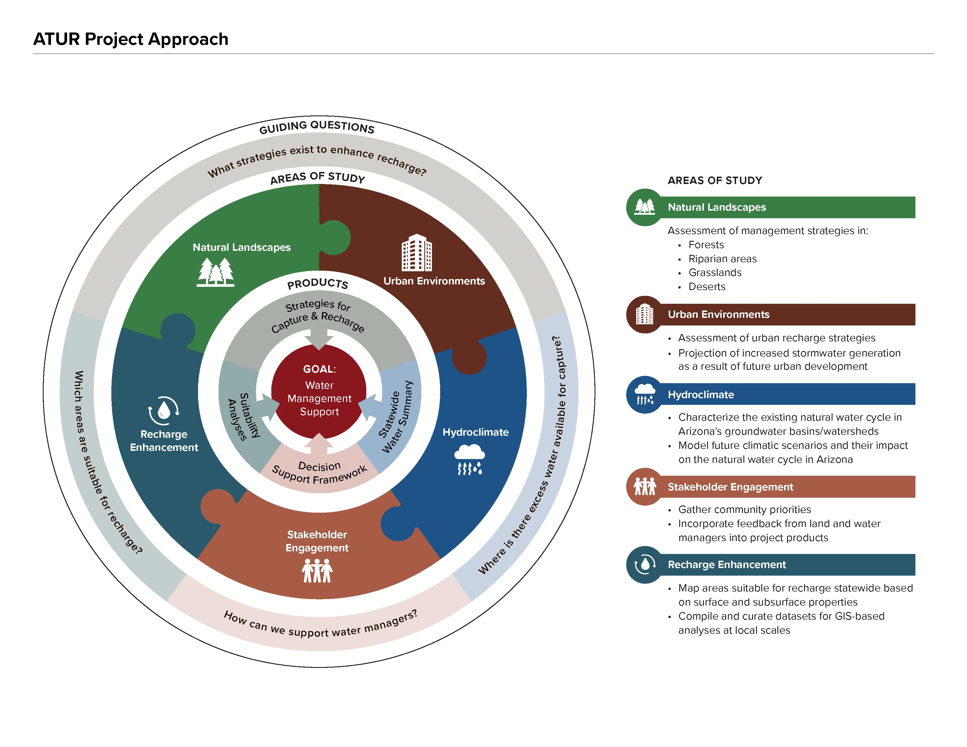
The Arizona Tri-University Recharge and Water Reliability Project (ATUR) has 5 subteams comprised of researchers, post docs, and graduate students from the three state universities, the University of Arizona (U of A), Arizona State University (ASU), and Northern Arizona University (NAU):
- Forests and Natural Environments Subteam
- Urban Environments Subteam
- Hydroclimate Subteam
- Recharge Alteration/Enhancement Subteam
- Stakeholder and Partner Engagement Subteam
While focused on their individual topic areas, the researchers integrate data, methods, and products across subteams. The Hydroclimate team is evaluating both present and future water balances across the state to develop a statewide water summary. The Recharge team is identifying locations where geology and hydrology are suitable for recharge. The Landscape and Urban teams have identified interventions for enhancing capture and recharge in both natural landscapes and urban environments. The Engagement team is focused on team coordination, science communication, and the integration of stakeholder feedback into project deliverables to ensure usable science. Together, this work culminates in support for water managers in prioritizing potential recharge locations and methods.
Methods
Estimate current and projected future precipitation, evaporation, recharge, and surface water runoff across the state by integrating observations, remote sensing products, and hydrologic models.
The ATUR Hydroclimate team is mapping existing and projected future hydrologic fluxes in Arizona’s groundwater basins. To our knowledge, this is the first time this type of basin-scale analysis is being done at a statewide level. Historical hydrologic fluxes (1980-2020) have been mapped through the use of the National Oceanic and Atmospheric Administration’s (NOAA) National Water Model (NWM) and Noah land surface model with multiparameterization options (Noah-MP), which provide gridded outputs for precipitation, evapotranspiration, surface runoff, groundwater recharge and other variables statewide. Model outputs are evaluated against on-the-ground data (stream gages, eddy covariance flux towers, snow telemetry stations, etc.) where available. The Hydroclimate team is currently working on future projections of water balance components statewide using downscaled general circulation models of future climate.
In addition to climatic changes, urbanization has an impact on water available for capture through increased runoff. The Urban team is using the Environmental Protection Agency’s Integrated Climate and Land Use Scenarios (ICLUS) to model land use changes in the context of climate change and understand the potential for capturing increased stormwater from urbanization.
Map surface and subsurface geology to identify areas where water can readily recharge aquifers.
The Recharge team is examining surface and subsurface properties across the state to identify areas suitable for groundwater recharge. This includes the compilation of recharge suitability parameters including geologic and soil properties, land surface properties, land cover type, depth to water, etc., and combining these parameters with specific weighting criteria to provide an assessment of recharge potential across the state.
Identify applicable strategies for capture and recharge for both urban and natural environments.
The Landscape and Urban teams are using a combination of empirical analyses, remote sensing, and publicly available models to investigate the impact of land management practices on the hydrologic cycle and enhancing recharge. Specifically, the Landscape team uses models including SnowPALM, ECOSTRESS, and Noah-MP along with empirical analyses and remote sensing to investigate the impact of forest thinning, wildfires, and stream channel management on hydrologic components (evapotranspiration, soil moisture, runoff, etc.) that affect recharge in natural areas. The Urban team employs both empirical analyses and models such as KINEROS2 and HYDRUS 1-D combined with machine learning to evaluate recharge strategies such as retention/detention basins and drywells in urban areas.
Integrate project findings into a decision-support framework to guide identification of locations for enhanced recharge projects and recommendations for capture and recharge interventions.
ATUR findings and tools are being integrated into a decision-support framework for natural resource managers working to address inadequate water supplies for both human and environmental uses. This framework incorporates consideration of groundwater management objectives, scale and location of the proposed solution, available water sources, recharge threshold criteria, capture and recharge opportunities, and potential costs, benefits, and limitations of possible options. In addition, example use cases are being developed to supplement the framework based on findings from ATUR’s stakeholder engagement efforts, representing groundwater management challenges and insights from the Arizona Department of Water Resources (ADWR) and other land/water management agencies, flood control districts, agricultural groups, and environmental organizations.
This framework is being developed by the Engagement subteam, which coordinates and helps integrate the technical expertise of the other four ATUR subteams, translate scientific findings into accessible information for managers and practitioners, and incorporate feedback from stakeholders into technical analyses. Since the start of the project, ATUR has engaged with 30+ organizations (land and water management agencies, Indigenous communities, environmental research and policy groups, agricultural groups, etc.) through over 70 engagement events to ensure research products are useful to practioners' ongoing work.